Sunday, May 18, 2025
What if billions of years ago, the Red Planet had rain, snow, and even rivers that carved out landscapes much like those we see on Earth?
That’s precisely what Dr. Amanda Steckel’s research suggests! In a recent episode of SETI Live, Dr. Steckel shared how her computer simulations revealed new clues about Mars’ ancient climate. Planetary scientist Beth Johnson and Dr. Steckel, a Caltech postdoctoral researcher, discussed this study's results and its implications for finding signs of life on Mars.
Investigating Ancient Martian Climate

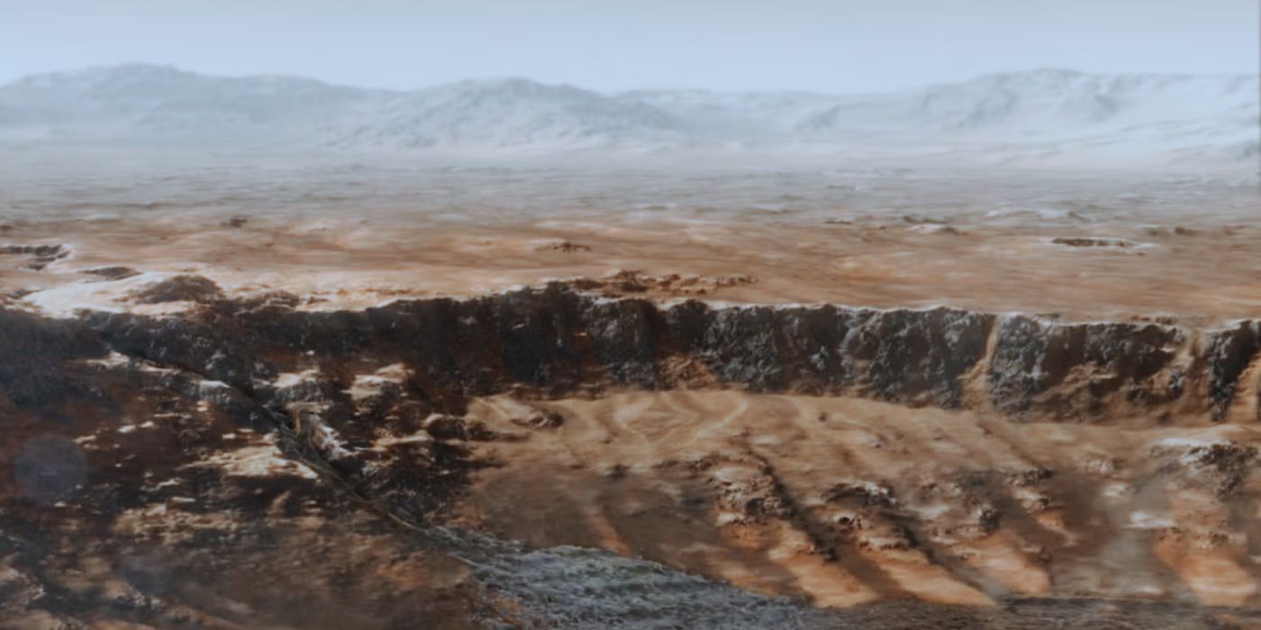
Dr. Steckel and her team focused on Martian valley networks — dry formations resembling riverbeds. These formations indicate that water once flowed across the surface, carving paths through the rock. However, the source of the water remains unknown.
The team proposed two possible explanations for the formation of these valley networks. To explore this, they set out to test two scenarios:
- Water was released solely from high-altitude ice caps
- Water came from precipitation, such as rain, snow, or ice
They aimed to determine which of these scenarios best explains how water shaped the Martian landscape.
How was the Research Done?
To test their ideas, the researchers used computer simulations. They employed landscape evolution modeling software called LandLab, which was developed at the University of Colorado Boulder. This tool allowed them to simulate how water would erode the Martian surface over long periods, specifically, over 600,000 years.
The process began by constructing a digital elevation model of a Martian region using laser altimetry data collected by satellites orbiting Mars. The researchers divided the terrain into a grid, with each point representing a specific location on Mars' surface. They then applied physical principles to simulate how different water sources influence erosion.
Why Look at Mars' Ancient Climate?
Here are the top three reasons scientists are fascinated with Mars’ past:
- Mars lacks active plate tectonics: Unlike Earth, Mars doesn’t have tectonic plates that constantly recycle and reshape its surface. On Earth, this tectonic movement and erosion erases the oldest rocks. But on Mars, ancient rocks — some over four billion years old — have been preserved.
- Mars has experienced global climate changes: Such planet-wide shifts are rare and challenging to study elsewhere. Understanding how and why these changes occurred could offer valuable insights into how planets evolve.
- Mars may have once supported life: One of the biggest questions is whether life once existed on Mars. For that to happen, the planet would have needed water. While scientists have long suspected Mars once had water, Dr. Steckel’s research suggests it might not have been limited to ice or underground reservoirs — it may have fallen from the sky as rain or snow.
What did the Simulations Reveal?
The team focused on a broad region around Mars’ equator, between 20 degrees north and 20 degrees south. They examined the starting point of the valley networks, known as valley heads. And they found that these features appear across a wide range of elevations, from about -1,800 to +3,500 meters.
Next, they compared their computer simulations to actual Martian data. The results showed that the scenario involving precipitation (rain, snow, or both) most accurately reflected the observed distribution of valley heads.
This finding supports that precipitation significantly shaped Mars’ surface, allowing water to carve valleys at different elevations.
Understanding Martian Landscapes
Another part of the research focused on the distinctive shape and pattern of Mars’ valley networks. Dr. Steckel described them as "dendritic," meaning they branch out like tree limbs or leaf veins. Similar patterns can be seen in major river systems on Earth, such as the Mississippi and Missouri rivers.
The team studied seven of the largest and most complex valley systems on Mars, in regions believed to have been the warmest and wettest in the planet's history. The structure of these valleys provides further evidence that precipitation was the driving force in their formation.
What’s Next?
Dr. Steckel highlights the potential value of the dataset for future research.
“I’m hoping that this dataset becomes a nice tool that people can use in climate models to reproduce,” she said. “I think that’s the real value of this project.”
By generating quantifiable and usable data from Mars’ surface, her work lays the groundwork for even more detailed modeling of the planet’s climate history.
Currently, Dr. Steckel is a member of the Mastcam-Z team on NASA’s Perseverance rover, contributing to both scientific research and rover operations. She is also expanding her focus to the Moon, contributing to the Lunar Trailblazer mission and analyzing data related to water ice on the lunar surface.
Looking Back to Understand What’s Ahead
Studying Mars’ ancient climate isn’t just about exploring its past — it’s also about deepening our understanding of how planets evolve. By examining the traces left behind by water, scientists are piecing together a story of how habitable environments emerge and disappear.
To learn more, check out the research paper, watch the video below, or find Red Planet, Blue Past: How Rain Shaped the Martian Landscape on our YouTube channel.
News
Related News
May 27, 2025
Planetary Picture of the Day - Week of May 19, 2025
#PPOD
May 20, 2025
Planetary Picture of the Day Week of May 12, 2025
#PPOD


May 15, 2025
Lunar Anomaly Detection: How AI is Transforming Moon Exploration
#Moon #Solar System #SETI Live Blog
May 27, 2025
#PPOD
May 20, 2025
#PPOD
Planetary Picture of the Day Week of May 12, 2025
May 15, 2025
#Moon
#Solar System
#SETI Live Blog
Lunar Anomaly Detection: How AI is Transforming Moon Exploration
Research
Related Projects

Technosignatures SAG • Technosignatures
Technosignatures SAG
Technosignatures SAG is a group of volunteer experts who have been chartered by NASA to produce a report to NASA’s Exoplanet Exploration Program, containing the results of its analysis on how NASA can better integrate technosignature search into its portfolio. #Technosignatures SAG #Technosignatures
GNU Radio • Radio Astronomy
GNU Radio and SETI
GNU technology could revolutionize the development of receiving equipment for SETI (and for radio astronomy in general.) It promises to speed the design of new receivers, and to allow scientists to quickly change how data are analyzed and displayed. #GNU Radio #Radio Astronomy
LaserSETI • Optical SETI
LaserSETI
SETI Institute’s LaserSETI program is building a network of instruments to monitor the entire night sky. This network represents an unprecedented growth in the continuing search for manifestations of sophisticated intelligence beyond Earth. #LaserSETI #Optical SETI
May 6, 2025
Technosignatures SAG
Technosignatures SAG is a group of volunteer experts who have been chartered by NASA to produce a report to NASA’s Exoplanet Exploration Program, containing the results of its analysis on how NASA can better integrate technosignature search into its portfolio.
#Technosignatures SAG
#Technosignatures
Apr 25, 2025
GNU Radio and SETI
GNU technology could revolutionize the development of receiving equipment for SETI (and for radio astronomy in general.) It promises to speed the design of new receivers, and to allow scientists to quickly change how data are analyzed and displayed.
#GNU Radio
#Radio Astronomy
Apr 25, 2025
LaserSETI
SETI Institute’s LaserSETI program is building a network of instruments to monitor the entire night sky. This network represents an unprecedented growth in the continuing search for manifestations of sophisticated intelligence beyond Earth.
#LaserSETI
#Optical SETI
Support Us
Support the
SETI Institute
Scientists are getting closer in their search for life beyond earth. But with limited federal funding for the search for extraterrestrial intelligence, supporters are the reason cutting-edge scientists can keep their eyes on the sky.